
Everything you need to know...
-
What is the fee?
Home: £10,620 for the course
International/EU: £17,725 for the course -
How long will I study?
1 Year
-
Where will I study?
-
When do I start?
January 2026
Course summary
- Gain advanced skills in implementing Geographical Information Systems (GIS).
- Apply GIS to map and analyse real-world problems.
- Develop your ability to communicate complex concepts to a range of audiences.
- Increase your employability skills by working on live projects in the industry.
Geographical Information Systems are increasingly important for understanding our changing planet. On this course you’ll develop cutting-edge skills while exploring the power of GIS – for both analysing and communicating spatial data. Along the way you’ll gain real-world experience in a range of industrial and academic sectors, giving you the knowledge and skills you need to kickstart your career.
Student satisfaction
This course scored 100% for overall student satisfaction in the Postgraduate Taught Student Satisfaction Survey 2025.

Come to an open day
Find out more at our postgraduate open days. Book now for your place.
How you learn
The course provides a balance of academic and practical content, enabling you to apply GIS to real-life scenarios. You’ll be taught by staff with a range of academic and industry experience, who apply their GIS skills to produce world-leading research.
We’ll challenge you to use GIS to understand our changing world, to find solutions, and to communicate with different audiences. Most sessions are taught through interactive practical exercises, with support provided by a tutor. You’ll also have short lectures and opportunities for group discussion and collaboration.
You learn through:
- Interactive practical exercises
- Engagement with external professional collaborators
- Tutorials
- Work-based placements
- Live projects
- Lectures
- Guest lectures
- A virtual learning platform
- Self-directed study
Course support
You will be supported in your learning journey towards highly skilled employment through a number of key areas. These include:
- access to specialist support services to help with your personal, academic and career development.
- access to our Skills Centre with one-to-ones, webinars and online resources, where you can get help with planning and structuring your assignments
- industry-specific employability activities such as live projects and networking opportunities
Applied learning
Live projects
Through the GIS Professional module or your independent project, we offer opportunities to work with industry and bodies like the British Cartographic Society. Previously this has included the Environment Agency, South Yorkshire Forest Partnership, Kew Gardens and United Utilities.
On the GIS Professional module you’ll take on work commissioned by a client organisation. Here you’ll engage with the client – giving you valuable real-world experience and problem-solving skills. Previous students have worked on projects such as analysing the Manchester bus network, conducting detailed geological mapping, and identifying new sites for local businesses.
Field trips
The course includes site visits with employers who have won awards for their innovative use of GIS.
Networking opportunities
We’ll prepare you to attend and network at a large GIS conference.
Members of the teaching team also have extensive professional experience and contacts within the GIS field. These will influence teaching and advise you on employability-based issues in tutorials.
Course leaders and tutors

Niall Gandy
Lecturer in GISNiall is a palaeo-glaciologist and GIS specialist, primarily lecturing in GIS at Sheffield Hallam University.
Student success story

"My work helps to lessen the impact of natural disasters."
Jack Lewis, MSc Geographical Information Systems.
Modules
Important notice: The structure of this course is periodically reviewed and enhanced to provide the best possible learning experience for our students and ensure ongoing compliance with any professional, statutory and regulatory body standards. Module structure, content, delivery and assessment may change, but we expect the focus of the course and the learning outcomes to remain as described above. Following any changes, updated module information will be published on this page.
Final year
Compulsory modules
In this module you will expand your knowledge and application of cutting-edge GIS techniques. You will focus on new emerging technologies in GIS, including AI and cloud computing, and plan for your continued professional development to keep pace with the advancing field.
You’ll study topics such as:
- Spatial statistics
- AI and machine learning
- Python and SQL
- Network analysis
- Spatial autocorrelation and hotspot analysis
In this module you will apply your expertise to a professional context. You will experience the use of GIS in a range of professional contexts, and apply your skills to a real-life project in partnership with colleagues in the industry.
You’ll study topics such as:
- Contacting clients
- Site visits
- Effective GIS consultancy
- Professionalism and CV skills
- Making the most of conference attendance
In this module you will advance our understanding of the world though the application of your professional skills. You will plan and execute an independent project, with a freedom to explore the range of topics that your developed skillset allows.
You’ll study topics such as:
- Working as part of a research group
- Identifying research gaps in the literature
- Writing a research proposal
- Executing independent research
In this module you will use data collection and GIS analysis techniques to monitor change, and then communicate your findings effectively online.
You’ll study topics such as:
- Remote Sensing and Drone monitoring
- Error classification
- GIS and the Internet of Things
- Statistical Downscaling
- Online data presentation
This module develops your toolkit of skills to understand society and the natural environment. In this module, you will integrate core GIS skills with the broader fieldwork, literacy, numeracy, and presentation skills that a modern GIS professional requires.
You’ll study topics such as:
- Geographical Information Systems
- Desk-based Site Survey
- Collecting field data
- Statistical analysis
- Python for Environmental Science
- Cartography
- Data plotting
Future careers
This course prepares you for a career in:
- GIS technician roles
- Strategic analysis
- Environmental modelling
- Data analysis
- Research
- Statistics
- Planning
Previous graduates of this course have gone on to work for:
- The Environment Agency
- The Sheffield and Rotherham Wildlife Trust
- Amazon Web Services
- Scottish Forestry
- Yorkshire Water
- ESRI
- Moors for the Future
Equipment and facilities
Students have access to specific GIS computer suites and remote-access software.
Explore Redmires
Explore Redmires
Study in the new Redmires building – home to law, social sciences and architecture at Sheffield Hallam University.
Entry requirements
All students
A lower second class degree or above in a relevant subject ensures consideration for entry on to the course. You may also be able to claim credit points which can reduce the amount of time it takes to complete your qualification at Sheffield Hallam. Find out more
Individuals without a suitable degree will be considered where they can demonstrate they meet the applicant entry profile and have worked for two years at a management level using GIS in the workplace, or, have a sufficiently high level of technical ability and responsibility within their role to meet the satisfaction of the admissions tutor.
If English is not your first language you typically need an IELTS 6.0 score with a minimum of 5.5 in all skills or equivalent.
Additional information for EU/International students
If you are an International or non-UK European student, you can find out more about the country specific qualifications we accept on our international qualifications page.
For details of English language entry requirements (IELTS), please see the information for 'All students'.
Fees and funding
Home students
Our tuition fee for UK students starting full-time study in 2025/26 is £10,620 for the course.
If you are studying an undergraduate course, postgraduate pre-registration course or postgraduate research course over more than one academic year then your tuition fees may increase in subsequent years in line with Government regulations or UK Research and Innovation (UKRI) published fees. More information can be found in our terms and conditions under student fees regulations.
International students
Our tuition fee for International/EU students starting full-time study in 2025/26 is £17,725 for the course.

Scholarships and financial support
Find information on scholarships, bursaries and postgraduate student loans.
International scholarships up to £3000 ›
Alumni scholarships up to £2000 ›
Postgraduate loans for UK students ›
Additional course costs
The links below allow you to view estimated general course additional costs, as well as costs associated with key activities on specific courses. These are estimates and are intended only as an indication of potential additional expenses. Actual costs can vary greatly depending on the choices you make during your course.
General course additional costs
Additional costs for Sheffield Institute of Social Sciences (PDF, 255.2KB)Legal information
Any offer of a place to study is subject to your acceptance of the University’s Terms and Conditions and Student Regulations.
Where will I study?
You study at City Campus through a structured mix of lectures, seminars and practical sessions as well as access to digital and online resources to support your learning.
City Campus
City Campus is located in the heart of Sheffield, within minutes of the train and bus stations.
City Campus map | City Campus tour

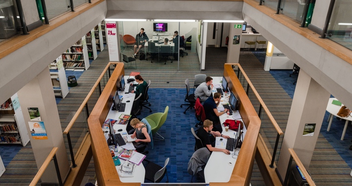
Adsetts library
Adsetts Library is located on our City Campus. It's open 24 hours a day, every day.
Explore the library